
Sources for Calhoun County Neighbors
No Calhoun County office publishes a ready-made neighbor list. The work falls to you. The map identifies adjacent parcel numbers, the Assessor supplies each account, and the Clerk's plats and deed records explain lot layout, roads, and easements. A library can add historic household context, though it proves nothing about current ownership.
| Source | What It Shows About a Block | Access |
|---|---|---|
| County GIS | Parcel polygons and nearby location context | Free county viewer; adjacent tool not verified |
| Assessor card | Owner name, mailing address, and account fields for each parcel | Free property search |
| Clerk plat or deed | Lot layout, roads, easements, and legal descriptions | Laserfiche or recorded instrument request |
| Library and Society | Historic family, cemetery, and community context | In person or by calling ahead |
The owner field names the party assessed, not every resident nearby. Mailing addresses often differ from the parcel. Some owners appear as entities or estates. Check each adjacent parcel separately before concluding anything about a shared boundary.
Calhoun County publishes no block-level neighbor report. This is a manual lookup. Keep the map labels and the Assessor card in separate columns, since one gives a location clue and the other identifies the account and its mailing details. An entity or out-of-county address may cover several parcels. That does not mean the parcels touch. Turn to the plat or legal description to confirm the physical relationship.
Calhoun County's Manual Parcel Method
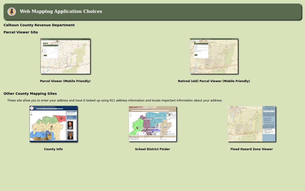
The county GIS page lists its mapping tools. A Parcel Viewer comes first. A mobile viewer, a 911 address lookup, a school district finder, and a flood hazard viewer round out the menu. No adjacent-parcel or buffer tool appears anywhere on the page. If the live map offers a select-by-location option, note the exact control. Otherwise, read the nearby map labels. Carry each parcel key to the Assessor.
Open the Calhoun County GIS choices page to reach the parcel viewer. The landing page displays the county's mapping links. It shows no sample adjacent-parcel card.
For a rural tract, begin with the 911 address lookup when the road name is unclear. Then open the parcel viewer from the county menu. The mobile map, County Info, school district, and flood tools are separate applications. Each has its own search fields. Do not assume the labels match. When a label confuses you, run the Assessor's Account or District/Map/Parcel fields first to pin down the tax record before hunting for a neighbor.
Locate your subject parcel before hunting nearby accounts.
Mapping Calhoun County Adjacent Parcels
Begin with one known address. Build a list of the tax parcels around it. The map shows which shapes sit beside the subject, and the Assessor returns the public card for any account you choose. A recorded plat or deed can confirm a shared boundary, road, or easement. There are no shortcuts here. A neighbor search in Calhoun County is parcel-by-parcel work.
- Locate the subject address with the county's 911 or parcel viewer.
- Write down each visible nearby parcel ID and note whether it appears to touch the subject.
- Run each ID through the Assessor and record the owner and mailing fields separately.
- Check a plat or deed when a shared line, road, or access right matters.
- Parcel ID
- The map and assessment key for a tax parcel.
- Adjacent parcel
- A neighboring tract that appears next to or shares a line with the subject.
- Buffer
- A map selection by distance; no county buffer tool was confirmed.
- Plat
- A recorded map that can show lots, blocks, roads, and easements.
Street Searches Around Calhoun Homes
The Assessor form includes a Parcel Address field. It offers no street-only search and no block list. The tax portal works differently. Its location mode searches by house number and street name, recommends the street name alone, and requires a roll type and year. An all-years choice does not exist in that mode. These fields can surface candidates. The map still decides which parcels are actually nearby.
Rural routes can carry old names or community labels. A Grantsville mailing city proves nothing about town limits. Check the county 911 address lookup and any municipal boundary information before trusting the label. Then compare the map against the deed description.
For street-only work, the tax search's location mode takes the street name without a house number. It still demands a roll type and tax year. The results list tax locations along the road, not a neighbor report. Nothing in them shows which parcel polygons adjoin. Narrow the candidates, then turn to the map, and pull alternate road names from the deed if the modern label comes up empty.
Plat Evidence for Calhoun Neighbors
Plats answer the why behind Calhoun County parcel shapes. A recorded plat can reveal the original lot pattern, block lines, road dedications, and easements. These details explain how two neighboring parcels meet. The Calhoun County Clerk keeps two useful entry points. One is an Index to Map and Plat Record 1; the other is a Laserfiche collection of recorded maps. Inside Laserfiche, the Clerk directs users to choose Browse, then County Clerk. A prefilled cookie message may appear at first, and Sign Out clears it.
Grantsville's 1866 town plat shows why the recorded map matters. A replat filed later can supersede an old lot label. Historic family or farm names often differ from modern subdivision names. For a full parcel map tour, the Calhoun County parcel maps reference covers the countywide layers. This lookup stays narrow, focusing on the parcels that touch one subject parcel.
Map Timing and Calhoun Parcel Changes
Map timing matters in Calhoun County. The statewide assessment viewer updates once a year. It warns that parcel geometry can lag behind a split. Transfers run between July 1 and June 30. Assessors revise the tax maps for that window. They submit them by February 1 of the next calendar year. A newly divided parcel may still look wrong after two years. The state's advice is to call the local Assessor then. These windows describe map maintenance, not a guarantee that an adjacent line moves on a set day.
A split can leave three things out of sync. These are the map label, the assessment account, and the recorded legal description. Write down the map date and the exact ID displayed. Then compare the parent and resulting parcel descriptions in the deed or plat. That side-by-side check settles most mismatch questions. The issue may involve an access strip, a private road, or a shared boundary. In that case, trace the recorded easement and any survey. Visual adjacency alone never establishes a right to cross or maintain land.
A split can reshape the neighborhood picture. Pull both the current Assessor card and the filed plat or deed. A GIS line is often a best-fit tax reference rather than a legal boundary. For a present owner's name, use the Calhoun County current owner record route. It compares the card against the newest deed. The two documents together give the owner of record with far more confidence than the map alone.
Privacy Limits on a Calhoun County Neighbor Lookup
A Calhoun County neighbor lookup has real limits. It can identify parcel records and owner names. It cannot identify everyone living on a street. West Virginia law recognizes stalking and harassment limits, and the state's Address Confidentiality Program gives eligible survivors substitute mailing addresses. Property records serve boundary questions, title diligence, local history, and civic purposes, never watching or targeting people.
Lawful use. Use Calhoun County adjacent-parcel records for legitimate property and civic research. Do not use owner details to track, stalk, harass, threaten, or harm anyone.