
How a Calhoun County Property Search Works
The Calhoun Assessor makes the best first stop for a modern property search. Its free page accepts Owner Name, Parcel Address, Account number, District, Map/Parcel, Property Type, Legal Description, and Deed Book/Page. An address is easy to recognize at a glance. A parcel or account number is the more exact key once you hold it. Owner-name searches can pull up several tracts. They can also miss a record entirely. That happens when punctuation, initials, or an entity suffix differ from the filing.
Keep a short worksheet as you move between systems. Write down the owner exactly as displayed. Include both addresses, the account, District, Map/Parcel, legal description, and deed reference. Then compare those details against a recorded instrument and the tax year in question. The sequence matters. The Assessor, Clerk, Sheriff, and GIS do not share one combined database.
- Enter the address or owner in the Assessor's Property Record Search and note the matching account.
- Copy the District, Map/Parcel, legal description, and deed book/page from the result.
- Search the County Clerk's modern portal or older index by party name and instrument clue.
- Check the Sheriff's tax portal with the correct roll type and year, then locate the parcel in GIS.
- Ask the custodian for an inspection or copy if the indexed result does not expose the needed document.
Calhoun County Assessor Search Inputs
The county's search form is more precise than a basic name lookup. Each input targets a separate record field. The page does not promise partial matching or offer a year selector. When a property address fails, try a known owner name or parcel key. Then confirm the card against its legal description. The Assessor supplies the data without warranties.
| Field | Type | Format or Use |
|---|---|---|
| Owner Name | Text | LAST NAME FIRST NAME, no comma |
| Parcel Address | Text | Situs or property address; exact matching behavior is not stated |
| Account # | Text | County account identifier |
| District and Map/Parcel | Select and grouped inputs | Four map/parcel segments are visible; local masks are not documented |
| Property Type | Select | Options were not exposed in the inspected text |
| Legal Description and Deed Book/Page | Text fields | Use the description or recording reference as a cross-check |
The official Calhoun County Assessor Property Record Search works best when you try one clear input at a time. The search fields help you narrow a parcel before a result is opened, and they separate an owner query from an account or map/parcel query. Some details, such as last-sale information, should be confirmed on the live record itself.
The Assessor page displays the search controls that start the lookup. Choose your input type carefully. A clean owner, account, or parcel entry leads to a more reliable result card.
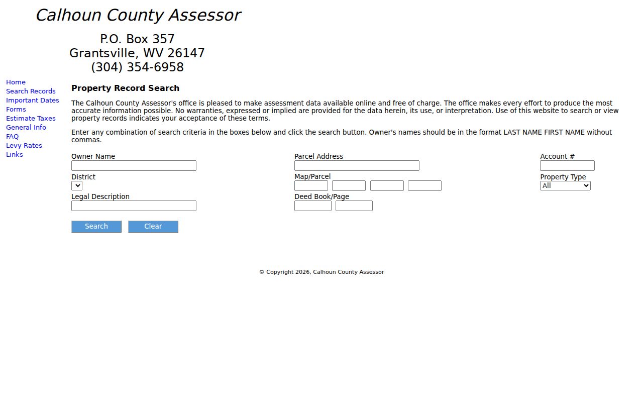
Once a candidate appears, preserve its exact fields. The same tract can then be traced through the tax, map, and deed sources without guessing.
What a Calhoun County Property Record Shows
A property search result is a starting card, not a full chain of title. The Assessor's form identifies fields linking a parcel to an owner, address, map key, class, legal description, and deed reference. Result labels appear only after a live query runs. Check the portal itself to see the exact labels and whether a sale price shows.
| Owner of record | Name entered on the assessment card; verify the exact result label |
|---|---|
| Situs and mailing address | Parcel location and tax-notice destination may differ |
| Account and Map/Parcel | Local key that helps match GIS and tax records |
| Property type and value | Assessment details; the landing page does not state the coverage year |
| Legal description | Deed-based description, such as lot/block or metes-and-bounds |
| Deed book/page | Reference for a County Clerk instrument search |
The field inventory is a guide to what the search page accepts, not proof that every field appears on each result. An LLC, trust, estate, or same-name owner needs extra checking. Match the parcel key and legal description to the deed before treating a result as the right property.
Owner Names in Calhoun County
The Assessor specifies LAST NAME FIRST NAME, with no commas, for owner searches. A complete entry may fail. Start with the surname instead, but treat each match as a candidate. Rural families often share names. A record may sit under an LLC, trust, estate, or fiduciary. That holder may not be the person who once occupied the land. The page documents no rules for result counts, sorting, or partial names. Compare the mailing address, account, property type, District, Map/Parcel, and legal description. Only then settle on a match.
A registered agent found in the West Virginia SOS business search is a contact for an entity. It is not proof the agent owns a parcel. The deed names the party who received or transferred the property. When a fiduciary signs, probate or court orders may explain the authority behind the transfer. For a purchase check, record both the owner name and the deed book/page. A name-only result may include a release, mortgage, assignment, or a document for a different tract. Read the full instrument. That shows whether the filing conveyed land or only changed an encumbrance.
Rural Addresses and Parcel Keys
Calhoun addresses can use route names, rural roads, streams, or community names. These stand in for a dense town grid. A historic route may not match the current municipal boundary. A newer road name may not match it. A Grantsville mailing city may not match it either. Keep the situs address, mailing address, and legal description in separate notes. Each serves a different purpose.
The Assessor offers four visible Map/Parcel input segments. The exact local format is not published. The statewide viewer explains a root Parcel ID. It is built from county code, district, map number, parcel prefix, suffix, and special ID. The state example comes from another county. It should not be copied as a Calhoun number. Use the string exactly as shown, zeroes and hyphens included.
- Situs address
- Where the land or improvement is located.
- Mailing address
- Where the tax notice is sent; it may belong to an owner, lender, or estate.
- Parcel or account
- The local key that ties the Assessor card to map and tax systems.
- Legal description
- The deed description that controls a transfer, such as a lot and block or metes-and-bounds calls.
Calhoun County Tax Portal Choices
The Sheriff doubles as county treasurer for Calhoun County. It collects state, county, municipal, and school taxes. Its public tax application pairs one search option with a roll type. A tax year completes the pairing. A location lookup runs on a house number and street name. The site recommends the street name alone. An owner query should put the last name first.
Two other entry points exist. One is a property number; the other is a tax-bill number. The property number's example shows grouped segments. Copy it straight from the Assessor or the tax bill rather than guessing. Remember that a tax search is bound to its chosen year and roll. It is not bound to the date a deed was recorded. Turn to the Sheriff for payments, delinquencies, and tax-sale status. The Assessor holds the card and assessment details.
The portal's visible fields and year controls make the tax search a handy second check. Use it once an account number is known. Its instructions favor one search method at a time. Stacking fields may not behave like the address-and-owner search on the Assessor page.
Calhoun County Deed Search Window
The County Clerk's current official records start in 1992. Older indexes live on Kofile. Deeds run from 1845 to 1985. Deeds of trust span 1911 to 1985. These are index dates, though, not a promise that every scanned deed image opens online. Nothing describes the 1986 to 1991 transition, so ask the Clerk how a record from those years is retrieved.
A recent transfer belongs in the Clerk's modern records hub, searched by party or instrument details. An older chain works better with grantor and grantee names, then book/page and the legal description from the deed index. Plats are a different animal. The county clerk page stores them in Laserfiche, apart from the modern deed search. The county was organized in 1856. Earlier tracts may sit in Gilmer County records.
When a search result is missing, the County Clerk accepts questions at P.O. Box 230, Grantsville, WV 26147, phone 304-354-6725. The public page posts no current copy fees or counter hours, so confirm both before an in-person visit.
Search by Address, Owner, or Parcel
The best starting key depends on what you know. An address feels familiar. But it can be stale or entered differently. An owner name may find more than one tract and calls for careful disambiguation. Once discovered, an account or parcel number is the most exact key, while a legal description or deed book/page can bridge the assessment card to the County Clerk's record.
| Search Key | Best For | Where It Works | Watch Out |
|---|---|---|---|
| Address | Start with a known location | Assessor and county GIS address tools | Rural route names and old street labels may differ |
| Owner name | Find candidate cards tied to a person or entity | Assessor; Clerk party index for instruments | Use LAST NAME FIRST NAME and verify same-name matches |
| Account or parcel | Match one tax map record across systems | Assessor, tax portal, and GIS | Copy the local string as shown; exact masks are not documented |
Not a title search. A Calhoun County property search shows indexed and assessment data, not a guarantee of clear title. Read the recorded instrument and use a title professional for a complete title opinion.
When Calhoun County Search Needs a Request
Not every question ends online. The Assessor's landing page shows no result card. The Clerk does not state current image fees, either. For a missing deed, plat, assessment detail, or historical tax book, contact the custodian and ask for inspection or a specific copy. The County Clerk's email is calhounclerk@gmail.com, and its mailing address is P.O. Box 230, Grantsville, WV 26147.
West Virginia's Freedom of Information Act, W.Va. Code Chapter 29B, calls for a response as soon as practicable and within five days, excluding weekends and legal holidays. Name the record precisely. Give an account, book/page, plat index, tax year, or case number. A custodian may charge actual reproduction cost. Search labor is not billable. The five-day deadline does not promise that a large archive will be fully processed within that window.
Ask whether the record is open for inspection before ordering copies. Ask whether the copy comes plain or certified. Details can differ by record type even inside the same building, so ask about older indexes and paper files too.